


Arbor Lake Voting District, King County, Washington
About
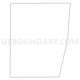
Outline
Summary
| Unique Area Identifier | 685089 |
| Name | Arbor Lake Voting District |
| County | King County |
| State | Washington |
| Area (square miles) | 0.20 |
| Land Area (square miles) | 0.19 |
| Water Area (square miles) | 0.00 |
| % of Land Area | 97.53 |
| % of Water Area | 2.47 |
| Latitude of the Internal Point | 47.49383850 |
| Longtitude of the Internal Point | -122.32868520 |
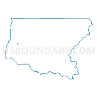
Maps


Graphs
Select a template below for downloading or customizing gragh for Arbor Lake Voting District, King County, Washington


Neighbors
Neighoring Voting District (by Name) Neighboring Voting District on the Map
- Bernice Voting District, King County, WA
- BUR 11-0289 Voting District, King County, WA
- BUR 11-0298 Voting District, King County, WA
- BUR 11-0824 Voting District, King County, WA
- Juniper Voting District, King County, WA
- Plato Voting District, King County, WA
- Victory Voting District, King County, WA
Top 10 Neighboring County Subdivision (by Population) Neighboring County Subdivision on the Map
Top 10 Neighboring Place (by Population) Neighboring Place on the Map
Top 10 Neighboring Unified School District (by Population) Neighboring Unified School District on the Map
Top 10 Neighboring State Legislative District Lower Chamber (by Population) Neighboring State Legislative District Lower Chamber on the Map
Top 10 Neighboring State Legislative District Upper Chamber (by Population) Neighboring State Legislative District Upper Chamber on the Map
Top 10 Neighboring 111th Congressional District (by Population) Neighboring 111th Congressional District on the Map
Top 10 Neighboring Census Tract (by Population) Neighboring Census Tract on the Map
- Census Tract 274, King County, WA (5,421)
- Census Tract 268.02, King County, WA (4,906)
- Census Tract 275, King County, WA (4,718)
- Census Tract 270, King County, WA (3,489)